
Geospatial Intelligence (GEOINT) is a key capability for national defence and security, in order to allow military forces to have detailed awareness of the physical geography and human activity within their own borders and maritime approaches, and the theatres their troops are or will be operating in.
The military appetite for GEOINT is immense, and growing. Having the best possible understanding of the physical and human geography of an area is a significant advantage for military and humanitarian operations planning, allowing precise decisions to be made prior to sending personnel, troops or first responders into a region.
The differentiator is persistence; the value in GEOINT lies in its being continually updated and informed by a range of imagery and mapping data sources. Such sources can be commercial and government satellites, reconnaissance aircraft and Unmanned Aerial Vehicles (UAVs). Such resources enable personnel to know that they are making decisions based on detailed up-to-date information to maximise mission success.
Eyes in Space
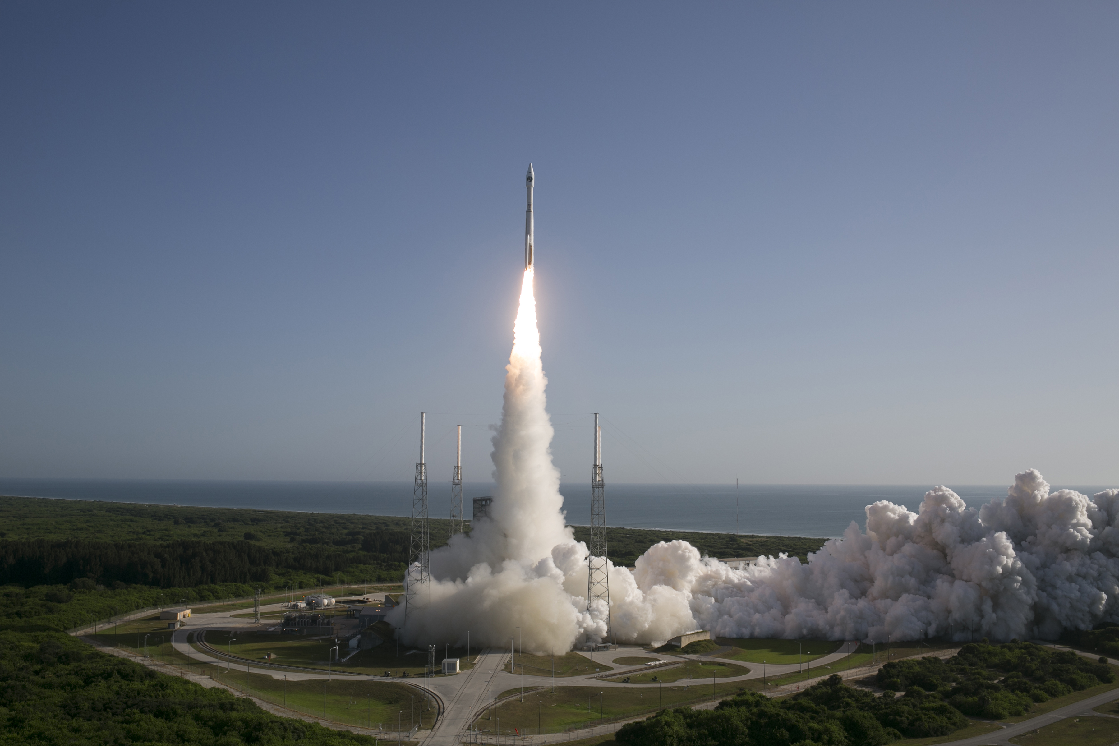
In order to have truly rounded GEOINT military forces take a layered approach to the assets they use to gather mapping and imagery data. At the top sit the government-owned satellites, such as the US NROL-45 satellite sent aloft on 10 February which may gather Imagery Intelligence (IMINT) for the US government, although the exact role of this satellite remains highly classified. Government-owned satellites gather IMINT worldwide or over specific areas of interest, usually on a daily basis, allowing a complex collection of IMINT to be gathered over time. These satellites can be used for various intelligence-gathering roles, with some undertaking more covert surveillance roles than others. The US keeps its reconnaissance satellites, operated by the National Reconnaissance Office (NRO), under wraps, with all operations and assets classified since the mid-1970s.
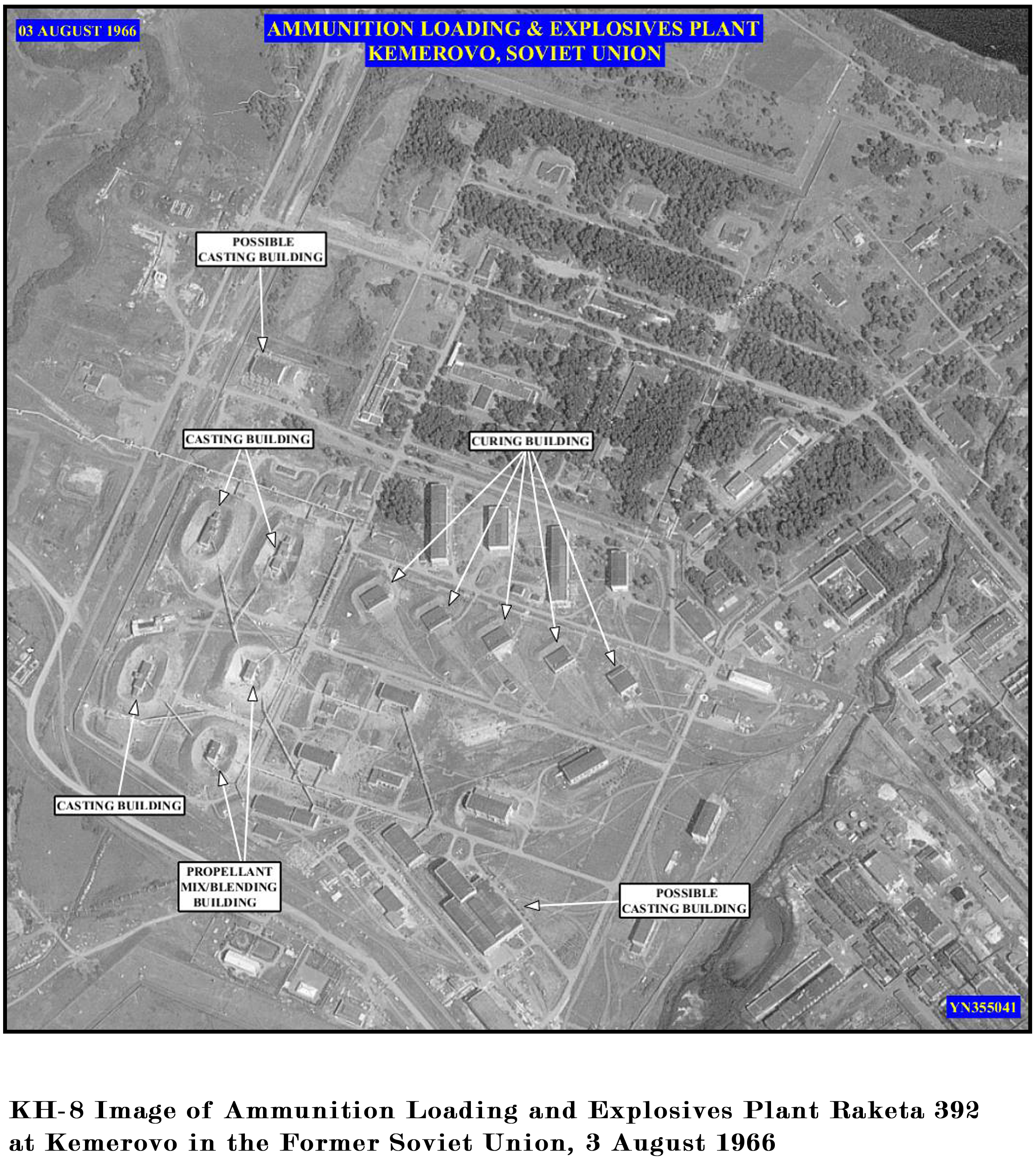
In recent decades the NRO has launched numerous satellites carrying payloads for GEOINT imaging, communications, naval signals intelligence (SIGINT), electronic signals intelligence (ELINT), and radar and optical imaging payloads for a range of classified surveillance missions supporting US national security. Three of the NRO’s older programmes—the KH-7 Gambit family, of which 38 were launched between 1963 and 1967, the KH-8 Gambit-3family and the KH-9 Hexagon family (20 launches between 1971 and 1985) IMINT satellites—were declassified in 2011, giving insight into the ‘eyes in space’ capabilities the US military benefited from during the Cold War. Together these systems provided new photoreconnaissance capabilities to penetrate denied areas of the Soviet Union, Eastern Europe and the Asia-Pacific.
The understanding that space reconnaissance assets provide information on the capabilities, intentions and advancements of those who oppose the US remains highly relevant for the US Department of Defence (DoD). In a speech at the 2010 National Space Symposium, an annual gathering of the US and international space community, the then director of the NRO Bruce Carlson said that the NRO was embarking on “the most aggressive launch schedule that this organisation has undertaken in the last twenty-five years,” with a number of “very large and very critical reconnaissance satellites that will go into orbit in the next year to a year and a half.”
The launch campaign continues apace, with three new satellites launched during 2016 alone including the NROL-45 discussed above, which has been joined in space by NROL-37 launched in June and NROL-61 launched in July, with a further launch scheduled for December.
High Altitude Assets
Given the resources it takes to build, launch and operate satellites that capture imagery of the ground, it is logical that most countries’ space assets are dedicated to communications rather than reconnaissance. As a result, many nations rely on data sharing agreements with those nations, such as the US, that prioritise spending in this area, and supplement their capabilities with other types of assets.
On 17 August the United Kingdom Ministry of Defence confirmed a move in this direction, with the news that it had ordered a third Zephyr-S UAV from Airbus’ defence and space division as part of a $17.2 million deal. The Zephyr-S is an ultra-lightweight ultra-high altitude UAV capable of flying at altitudes of 70000 feet/ft (5181 metres/m) for up to 45 days at a time, earning it the title of a High Altitude Pseudo Satellite (HAPS) because it performs more like a satellite than a conventional UAV. The first two units were ordered in February 2016. According to the MoD, the three UAVs will form part of an Operational Concept Demonstrator (OCD) trial throughout 2017 to assess the Zephyr-S’ capabilities and explore its potential for use by the UK armed forces as a next-generation battlefield intelligence capability. The UAV can carry payloads for communications and surveillance to provide persistent surveillance over land or sea; having three units will allow two airframes to be tested simultaneously and demonstrate operational handover to show that the capability has the potential to be sustained indefinitely. “The Zephyr-S … can carry a payload of about eleven pounds/lbs (five kilograms/kgs), but within that constraint we can work flexibly with the customer on the precise equipment,” Jana Rosenmann, head Of unmanned aerial systems at Airbus’ defence and space division, told Armada. “For the surveillance mission the Zephyr-S can be equipped with an optical and/or infrared camera providing centimetric resolution (and) we have undertaken the first steps in working on the next Zephyr-T version with twin-tails which will carry around four times greater payload and that takes us into the area where it will be able to carry a radar. So when you marry that to the underlying capability to remain on station over a given area for days or weeks at a time, we really have an incredibly powerful surveillance capability.”

Although the precise purposes for which the MoD will use its Zephyr-S UAVs have not been disclosed, it is likely to be a form of geospatial reconnaissance. The MoD said the acquisition is part of its plan for stronger and better defence, with their ability to gather “constant, reliable information over vast geographical areas at a much greater level of detail than ever before.” Ms. Rosenmann added, “Clearly the big attraction is the unique capability to provide persistent, satellite-like surveillance and with excellent economics … It is very obvious that there are scenarios right now where the Zephyr-S’ capability has huge potential; asymmetric conflicts being fought in vast desert areas for example, or disputes over large maritime territories. The precise applications that we are discussing with customers tend to be quite sensitive but I don’t think there is any question that the aircraft’s time has come.”
US Efforts
The US Air Force (USAF) also operates its High Altitude Long Endurance (HALE) asset, the Northrop Grumman RQ-4A/B Global Hawk UAV, in support of GEOINT operations. For around a decade the National Geospatial Intelligence Agency (NGA) has identified this UAV as a cost-effective data collection system to supplement national systems for its National System of Geospatial Intelligence (NSG) requirements. The NGA is part of the US Department of Defence and is responsible for gathering, analysing and distributing GEOINT.
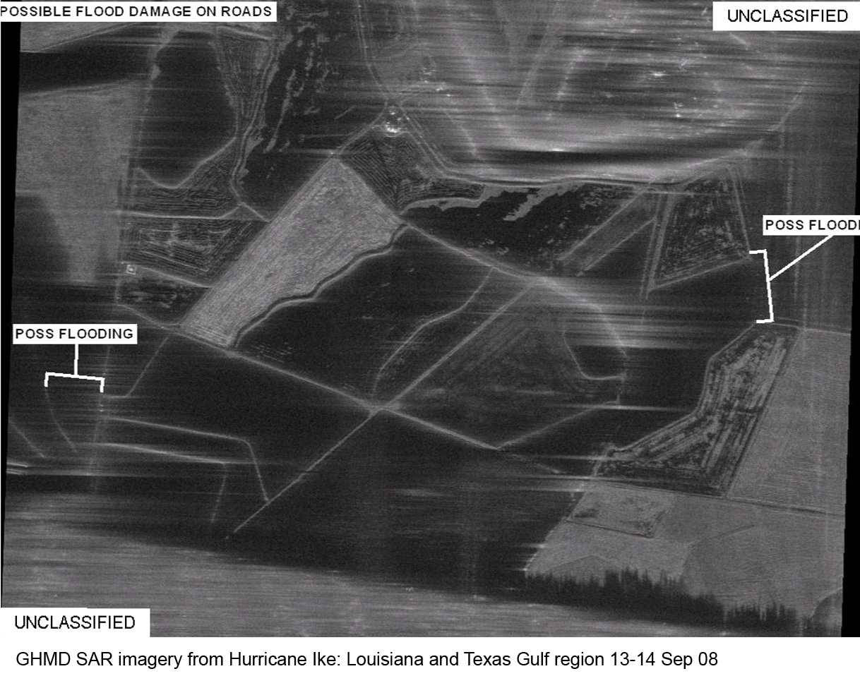
UAVs such as the RQ-4A/B are also important for multi-national operations, as the imagery they collect can be shared with allies without compromising the capabilities and operating characteristics of the US national reconnaissance systems. Along with the lower altitude General Atomics MQ-1A/B Predator family also operated by the USAF, the RQ-4A/B carries remote sensing payloads to gather GEOINT, including still imagery (visible and infrared), full motion imagery, Synthetic Aperture Radar (SAR) and light detection and ranging (LIDAR) and geophysical sensors that enables analysts to characterise the earth in different ways. For more information on LIDAR, please see the How It Works box accompanying this article.
How It Works: LIDAR
LIDAR (Light Detection and Ranging) uses ultraviolet and near-ultraviolet light. The light is transmitted, hits an object and the time it takes to return to the transmission source is measured. Given that the speed of light is constant at 161,987 nautical miles-per-second (300,000 kilometres-per-second), calculating the distance of an object is achieved by multiplying the speed of light by the time it has taken a light photon to travel from and to the light source and dividing this by two. LIDARs can typically fire up to 150,000 pulse of light per second at an object. By measuring the time it takes each of these pulses to return, it is possible to draw a very accurate ‘picture’ of the object being targeted.
Referenced in Space
The GEOINT process does not end with the capture of imagery by assets such as satellites and HALE UAVs. In order for the imagery to be useful to military operations it must be represented geographically. At its basic level this includes details of the terrain and the physical features of the landscape such as its gravimetric (measuring the strength of the Earth’s gravitational field), geomagnetic (the measurement of the Earth’s magnetic field), and hydrographic (measuring the physical characteristics of water) surveying data, so that decisions can be made within a geographical context. Mapping data can also be combined with information about the physical and human features of the landscape, such as buildings, the location of hazards and resources, so that military commanders can plan missions effectively.
This mapping data is usually provided by commercial satellite operators under contract to national governments. Depending on the service, the entire world’s surface may be mapped and rendered in 3D (three dimensions) so that all planning can be based on accurate and regularly-updated geo-referenced data. Airbus’ defence and space division provides this capability for a number of nations including the German MoD. The company’s TanDEM-X and TerraSAR-X satellites acquire high-resolution and wide-area images of the earth’s surface independent of weather conditions with unique geometric accuracy. “Homogeneous, globally available DEM (Digital Elevation Models which depict the ground’s elevation and topography) of high accuracy is a basic information layer for mapping and mission planning,” states Gertrud Riegler, head of SAR and WorldDEM product lines at the company. “Environmental disasters, humanitarian mission or political crises require fast mission planning no matter where in the world … The unrivalled accuracy on a global scale makes the WorldDEM the elevation model of choice for any military projects requiring global terrain information with a very high level of detail.” According to Dr. Riegler, military users are applying their tactical mapping capabilities for an increasing number of roles, including mobility option planning and heavy vehicle ‘trafficability’; that is the ability of heavy vehicles to use particular stretches of territory, optimised performance of smart weapon systems, aircraft navigation in low visibility conditions, low-altitude flight and obstacle avoidance systems, plus landing approach planning.
Decision Support
As sensors proliferate around the battlefield, there is a wealth of data being collected that can be used to add the final layer to geospatial intelligence resources, such as the quickly-changing actions of enemy or insurgent forces, the pattern of life pictures in a target area, or the build-up of offensive assets in a region. These decision support tools are the vital ingredients that enable decision-making to be based on real-time information with regard to both physical and human factors in the landscape.
Surveillance of the maritime environment is a growing area of interest for many nations, during a time when threats and humanitarian crises are increasingly encroaching from the sea. The UK government is currently working to expand its reconnaissance capabilities in maritime areas as it looks to address the lessons learned from recent operations, such as UK combat operations in Iraq between 2003 and 2009, regarding the need for persistent Intelligence, Surveillance and Reconnaissance (ISR).
According to the MoD in written answers provided to questions presented by the House of Commons Defence Committee (which supervises government defence policy) future maritime surveillance enquiry, reconnaissance capabilities, available for 24 hours a day for the duration of an operation, can be made up of “several different platforms with differing capabilities operating in unison. Situational awareness is generated and maintained through the synthesis of several maritime surveillance collection capabilities, overhead satellites, manned and unmanned platforms, and ships and submarines.”
According to the MoD, the UK exploits US satellite products, notably IMINT and SIGINT gathering processes, to support its wider maritime surveillance operations, along with purchased unclassified commercial satellite services for capabilities including high-definition imagery and Automatic Identification Services (AIS). The latter is a satellite communications-based vessel identification system mandated by the International Maritime Organisation for all vessels displacing in excess of 300 tons.
Now, steps are being taken to address the need for greater maritime surveillance from UK-owned assets. This capability is currently provided largely by surface vessels and submarines, with video and still surveillance imagery provided in part by the MoD’s Project Picasso. This provides a national capability for the provision of strategic IMINT and GEOINT to the MoD, to deployed forces and to other government departments through the exploitation of data gathered from national and multi-national collection assets.
The decision by the MoD in 2010 not to bring the Hawker Siddeley/BAE Systems’ Nimrod MRA4 Maritime Patrol Aircraft into service has reduced its conduct strategic intelligence gathering tasks, with no single asset capable of offsetting the resulting capability gap. To address this gap, a number of new acquisitions are being made. In 2016 the MoD announced a significant new programme, with the news that it will acquire nine P-8A Poseidon MPA. Confirmed in July, the aircraft will carry out high- and low-level airborne maritime and overland surveillance for extended periods, conducting wide-area search of oceans to locate small boats and drop rescue life-rafts and equipment to vessels in distress.

Creating Intelligence
The wealth of data available to create GEOINT is of use only if it can be arranged, integrated and extracted easily in a user-friendly way. This requires GEOINT processing systems that bring together all available data and allow the user to see what they need to know about an area of interest in real time, and to customise data to suit the mission at hand. Commercial providers play an important role here. Esri’s geographic information system ArcGIS is used by defence forces worldwide for creating maps, compiling geographic data, analysing mapped information, sharing and discovering geographic information, using maps and geographic information in a range of applications, and managing geographic information in a database.
ArcGIS supports military intelligence analysts with a platform for advanced analytic methodologies and innovative tools, allowing raw data to be converted into relevant information through spatial, temporal and contextual analysis. It fuses information from sensors, databases and field operators to provide understanding of the environment, and allows users to collaborate and share mission-critical information. Esri’s product is widely used in the UK defence community; the British Army Headquarters Land Forces (HQ LF) uses ArcGIS to coordinate military support for the emergency services, providing information on what facilities and resources are available, through the medium of maps. Military and civilian information is instantly available, with interfaces for existing databases and applications all presented with regards to where resources, hazards and incidents are located.
ArcGIS is also used for military air operations by the Royal Air Force to support the management, analysis and integration of geospatial data. It gives commanders the ability to plan air activities, visualise and understand the operational and tactical levels, ingest new information quickly and understand its context for missions such as dynamic targeting, personnel recovery and ISR.
Open Source
BAE Systems works with the NGA in this area (see above), supporting its Map of the World project as part of the NGA’s GEOINT Data Services Programme. The company will assist in transforming the collection, maintenance and utilisation of GEOINT data and products to provide solutions that give US military commanders clearer on-the-ground intelligence pictures to enhance situational awareness and mission planning. BAE Systems works with new data sources, including open source intelligence, and NGA archive data.

Open source data is becoming increasingly relevant as organisations look to harness the power of crowd source mapping for geospatial ‘big data’ analysis. The NGA is working with DigitalGlobe (as of June 2015) on an open source toolkit for collaborative mapping. The project, called Hootenanny (a Scottish word referring to a celebration), provides a scalable processing engine and interactive editing interface to enable rapid conflation of map features generated from satellite imagery, UAVs and mobile devices.
The system’s design is based on publically-available GEOINT, such as the user-generated mapping community Open Street Map, which use satellite imagery to capture the geometry and metadata (information) regarding roads, buildings, and points of interest to create high quality maps and enable analytical functions like routing, suitability analysis, or predictive modelling. Although drawn from unclassified sources, the resulting databases have the capacity to add value to classified data, and offer a model that can be replicated across different industries for cost-effective solutions for military organisations looking to supplement their GEOINT capabilities in certain areas.


 programme")